Rod Stock XSNGH Memorial Highway

Full map of ECV plaques: http://ecvplaques.com
To add a plaque: First, go to HMDB.org and input all current information. Next, fill out this Google form.
In Memory of Julia C. Bulette

In Memory of Julia C. Bulette
Angel of miners, friend of firemen
and administrator to the needy
Brutally murdered Jan. 20, 1867
Julia Omnio Servibus
Presented by Nevada Chapter
E Clampus Vitus, July 1963
Location. 39° 18.521′ N, 119° 38.984′ W. Marker is in Virginia City, Nevada, in Storey County. Marker is at the intersection of D Street and Washington Street, on the left when traveling north on D Street. Touch for map. Marker is in this post office area: Virginia City NV 89440, United States of America.
Pilgrim Rock

“Dedicated to the Clamp Pilgrims by the Julia C. Bulette Chapter, E Clampus Vitus, Virginia City, Nevada, August 22, 1963.”
Location: Plymouth, Massachusetts, bronze rock anchored to Pilgrim Rock
Ill-Fated Brothers
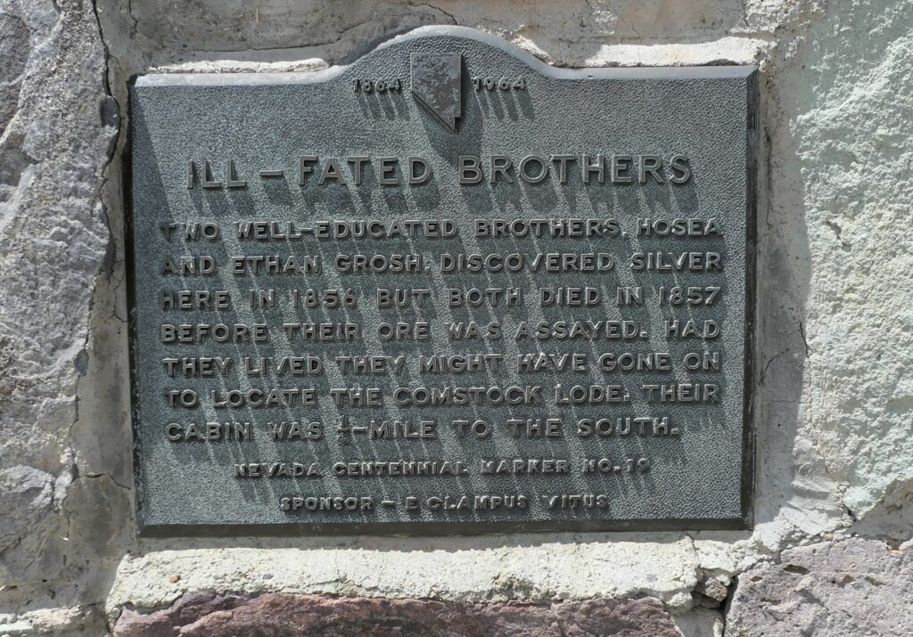
“Two well-educated brothers, Hosea and Ethan Grosh, discovered silver here in 1856 but both died in 1857 before their ore was assayed. Had they lived they might have gone on to locate the Comstock Lode. Their cabin was 1/2 mile to the south. Nevada Centennial Marker No. 19. Sponsor – E Clampus Vitus.”
Location: Silver City, NV, 7/4/1964.
Mayflower
Plymouth, Massachusetts, 8/5/1964. Plaque located at dock to which Mayflower is anchored.
Pioneer Cemetery

“In May, 1860 Major William Ormsby was killed in an ambush by Paiutes at Pyramid Lake. In June, 1860 William Allen, a scout, was the last of some 40 white men killed in the ensuing war. Both were interred here, but Ormsby was later reburied in N.Y.. Nevada Centennial Marker No. 27 Sponsor – E Clampus Vitus”
Location: Carson City, west end of 5th Street. 10/31/1964 39°09’40.7″N 119°46’46.5″W
Old Miners Union Hall

“The miners union was organized in 1867. The union fought for recognition, safety, family welfare, and a living wage $4.00 per day. this build-ing, owned and maintained since 1913 by Aerie 532 F.O.E., was built in 1876. The original hall was destroyed in the 1875 fire.
Nevada Historical Marker No. 30
Sponsor E Clampus Vitus
Location: 34 North B Street, Virginia City. 6/26/1965.
Gold Hill Hotel

“This building is the original stone and brick edifice erected on the site of the first recorded claim, on what became the Comstock Lode May 1, 1859. One of the earliest hotels, it housed miners and notables offering lodging, tavern and barbershop. Nevada Historical Marker No. 36. Dedicated June 18, 1966 by E Clampus Vitus.”
Location: Gold Hill, Nevada
Red Light District

Inscription. On this spot once stood the cribs of Virginia City’s “Sporting Row.” Near this site, in Crib 1, was housed the celebrated courtesan of the Comstock, Julia C. Bulette, brutally murdered January 20, 1867 for her jewels by John Millian.
Erected 1967 by E Clampus Vitus, Julia C. Bulette Chapter No. 1864. (Marker Number 37.)
Marker series. This marker is included in the E Clampus Vitus marker series.
Location. 39° 18.651′ N, 119° 38.941′ W. Marker is in Virginia City, Nevada, in Storey County. Marker is at the intersection of North D Street and Union Street on North D Street. Marker is at or near this postal address: 26 North D Street, Virginia City NV 89440, United States of America.
Johntown
(Site One Mile Down Gold Canyon)

Inscription. Nevada’s first mining town established in 1853. A boarding house was operated here by Eilley Orrum (Mrs. Sandy Bowers). Other prominent residents, discoverers of the fantastic Comstock Lode, included the Grosh Brothers, Peter O’Riley, Patrick McLaughlin, H.T.P. Comstock, and James Finney (Old Viginny).
Erected 1967 by E Clampus Vitus, Julia C. Bulette Chapter No. 1864. (Marker Number 39.)
Marker series. This marker is included in the E Clampus Vitus marker series.
Location. 39° 15.494′ N, 119° 38.124′ W. Marker is in Silver City, Nevada, in Lyon County. Marker is at the intersection of Occidental Grade (State Highway 341) and Old Dayton Toll Road on Occidental Grade. Marker is located just north of the intersection of Nevada State Highways 341 and 342. Marker is in this post office area: Silver City NV 89428, United States of America.
Ormsby House
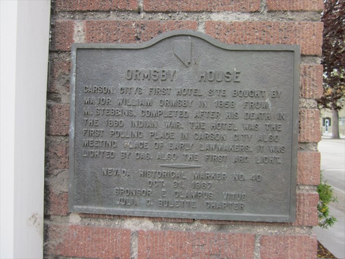
Inscription: Carson Citys first hotel site bought by Major William Ormsby in 1859 from M Stebbins, completed after his death in 1860 Indian War. The hotel was the first polling place in Carson City also meeting place of early lawmakers. It was lighted by gas, also the first arc light.
Nevada Historical Marker No. 40
Oct 31, 1967
Sponsor E Clampus Vitus
Julia C Bulette Chapter
Location: N 39° 09.970 W 119° 46.065 ; 11S E 260878 N 4338866
Virginia City Cemeteries
Inscription: “In Memory of the THOUSANDS OF NEVADA PIONEERS buried in the following Virginia City cemeteries – Baums, Brown east and west end, Catholic, China Mission, Chinese, Citizens Public, Pierce, Conboie, County Hospital, Exempt Firemen, Flowery Hill, Mt. Pleasant, Hebrew, County, Indian Burial Ground, Knights of Pythias, Masonic, Mount St. Mary’s, Odd Fellows, Pacific Coast Pioneers, Protestant, Redmen, Silver Terrace, Woodmen, Wilson and Brown, Virginia City Miners Union plots, the Vault. Nevada Historical Society Marker No. 38. Sponsor ECV 1967 Julia C. Bulette Chapter.”
Location: in Virginia City, at cemetery. 11/11/1967
Lake’s Crossing
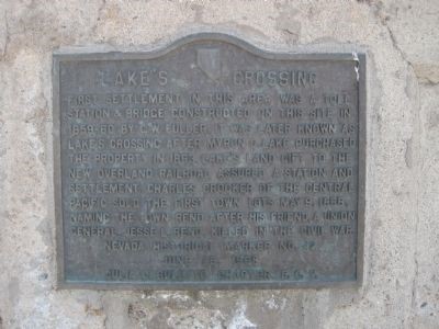
Inscription. First settlement in this area was a toll station & bridge constructed on this site in 1859-60 by E.W. Fuller. It was later known as Lake’s Crossing after Myron C. Lake purchased this property in 1863. Lake’s land gift to the new overland railroad assured a station and settlement. Charles Crocker of the Central Pacific sold the first town lots May 9, 1868, naming the town Reno after his friend, a Union general, Jesse L. Reno, killed in the Civil War.
Erected 1968 by Julia C. Bulette Chapter, E Campus Vitus. (Marker Number 42.)
Marker series. This marker is included in the E Clampus Vitus marker series.
Location. 39° 31.494′ N, 119° 48.751′ W. Marker is in Reno, Nevada, in Washoe County. Marker is on South Virgina Street (Nevada Route 430), on the right when traveling south. Touch for map. The marker is located on the west side of the south end of the Virginia Street Bridge over the Truckee River. Marker is in this post office area: Reno NV 89501, United States of America.
Lousetown

Inscription. North of this marker, a station was established in 1860 on Geiger and Tilton’s new toll road from Truckee Meadows, •• Fine springs, terminus of several wood roads, and a population of teamsters, stock and sheep men were found at Lousetown •• Nevada’s most unique name. The area included the first Virginia City railroad surveys, first ice project, and race track with trap shooting and picnic grounds. The first telegraph line to Reno and the largest toll station in the area in the area were in the vacinity [sic] of this marker.
Erected 1968 by Julia C. Bulette Chapter No. 1864, E Clampus Vitus,. (Marker Number 41.)
Marker series. This marker is included in the E Clampus Vitus marker series.
Location. 39° 21.099′ N, 119° 38.75′ W. Marker is near Virginia City, Nevada, in Storey County. Marker is on Geiger Grade Road (State Highway 341). Marker is in this post office area: Reno NV 89521, United States of America.
The Warren Engine Co.
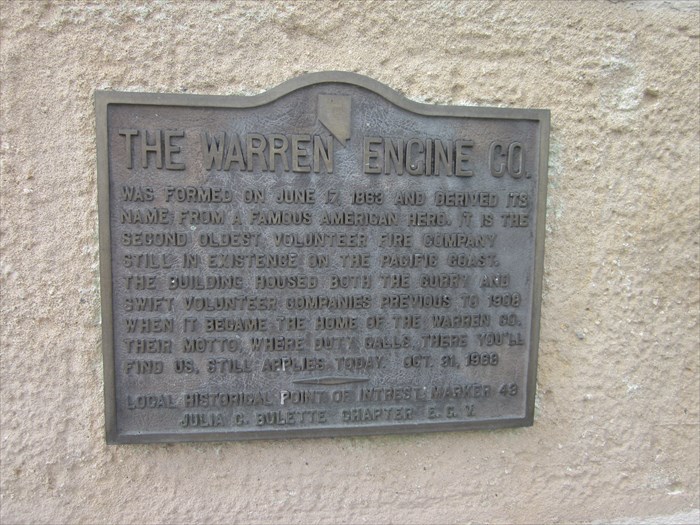
Inscription: The Warren Engine Co. was formed on June 17, 1863 and derived its name from a famous American hero. It is the second oldest volunteer fire company still in existence on the Pacific Coast. The building housed both the gurry and swift volunteer companies previous to 1908 when it became the home to Warren company. Their motto ” where duty calls, there you’ll find us” still applies to today. Oct. 31, 1968
Local Historical Point of Interest: Julia C Bulette chapter 1864. E Clampus Vitus.
Location: N 39° 09.879 W 119° 46.061 ; 11S E 260879 N 4338697
Hawthorne

Inscription. Present Mineral Co. Seat — Former Esmeralda Co. Seat
Townsite selected in 1880 by H. M. Yerington, president of the Carson and Colorado Railroad Co. as a division and distribution site for the new railroad.
The location was adjacent to the important Knapp’s Station and Ferry Landing on the busy Esmeralda Toll Road from Wadsworth to Candelaria
Radiating roads ran to all of the surrounding mining areas.
Yerington named the new town Hawthorne after a lumberman friend in Carson City and on April 14, 1881, the first train arrived, loaded with prospective buyers for the new town lots.
In 1883, Hawthorne took the Esmeralda County seat from declining Aurora but later lost it to booming Goldfield. In 1911, it again became a county seat, this time for the new Mineral County.
In 1926, a destructive munitions explosion in the east caused the military to select Hawthorne for a new site. In 1928, Governor Balzar, former citizen of Hawthorne, turned the first shovel of dirt and dedicated the new depot which officially opened in 1930.
Hawthorne is a central point for desert travelers and for the vacation activity on nearby Walker Lake.
Erected by Nevada State Park System, Julia C. Bulette Chapter, E. Clampus Vitus. (Marker Number 60.)
Marker series. This marker is included in the E Clampus Vitus marker series.
Location. 38° 31.958′ N, 118° 37.513′ W. Marker is in Hawthorne, Nevada, in Mineral County. Marker is on 10th Street.
Old Roundhouse and Railroad Station
Virginia City, Nevada, 6/28/1969. Plaque was located in Virginia City. Present Location unknown.
Mound House

“Mound House was located one-half mile north of this point. Originally constructed in 1871 as a station and siding on the Virginia and Truckee Railroad, it served for some time simply as a wood and water stop. In 1877, a post office was established. Mound House came into its own in 1880, when the V. & T. began construction of a narrow gauge railroad from here to the mining camps of western Nevada and the Owens Valley Region of California. Named the Carson & Colorado. It turned Mound House into a booming shipping point.
“The Southern Pacific Railroad purchased the C. & C. from the V. & T. in 1900. Just prior to the Tonopah silver strike, in 1905, the V. & T. built a short line from the new station at Hazen, on the main line, to intersect the C. & C. at Fort Churchill. The Hazen cutoff took most of the booming Tonopah-Gold Field business away from the V. & T.
“During the period 1900 – 1920, extensive gypsum mining and milling operations, to produce plaster, were carried on immediately northwest of Mound House.
“The narrow gauge line was abandoned from Mound House to Churchill in 1934, and the V. & T. track from Carson City to Virginia City in 1939. Within a few years, Mound House had disappeared. Nevada Historical Marker No. 61”
Location: 39° 12.867′ N, 119° 40.163′ W. Marker is in Dayton, Nevada, in Lyon County. Marker is on Lincoln Highway (U.S. 50) just east of Bunnyranch Road, on the right when traveling west. Marker is located approximately 11 miles southwest of Dayton on the north side of the highway. US 50 near junction State Route 17.
Town Hall
Inscription: “This building was originally the California Saloon and Brewery. It later became the firehouse, and is now the Virginia City Town Hall. The belfry was restored in 1972 by the Comstock Historical Restoration Foundation. The bell was erected by Friends of Florence Ballou Edwards. Julia C Bulette Chapter 1864, E Clampus Vitus.”
Location: Virginia City, inside Town Hall. 1969.
Sutro
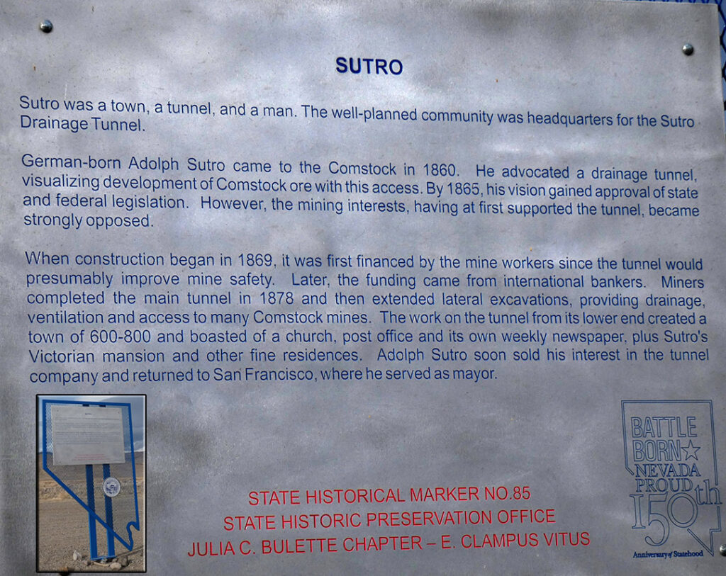
“Sutro was a town, a tunnel and a mine. The orderly town was the headquarters for the Sutro drainage tunnel. Adolph Sutro, daGerman born, came to the Comstock in 1860. He advocated a drainage tunnel, visualizing development of the Comstock resource by a system long used to drain and explore mineral deposits. By 1865, his vision gained approval of state and federal legislation. However, the mining interests having at first supported the tunnel became strongly opposed.
“When construction began in 1869, it was first funded by the mine workers, since the tunnel would improve mine safety. Later the funding came from international bankers. The main tunnel broke through in 1878 lateral tunnels were extended and the project drained, ventilated and serviced the Comstock as planned. When the tunnel was completed Adolph Sutro sold his in the tunnel company and returned to San Francisco.”
Location: 39° 16.462′ N, 119° 33.874′ W. Marker is in Dayton, Nevada, in Lyon County. Marker is at the intersection of Lincoln Highway (U.S. 50) and Segale Road, on the right when traveling west on Lincoln Highway.
Gold Hill Millionaires

Near this site is the Imperial Co. gloryhole that produced the first Comstock millionaires. Adjoining claims held by Eilley (Orrum) Cowan and Sandy Bowers, whom she later married. Produced over $1,000,000 in gold and silver. The Bowers Mansion in Washoe Valley, now a county historical park is all that remains of their fortune. Sandy died in 1868; Eilley, later known as the “Washoe Seeress” in 1903. Julia C Bulette Chapter E Clampus Vitus October 31, 1970
Location: 39° 17.639′ N, 119° 39.444′ W. Gold Hill Train Depot, 1455 N Main St, Silver City, NV 89428
Ophir Grade
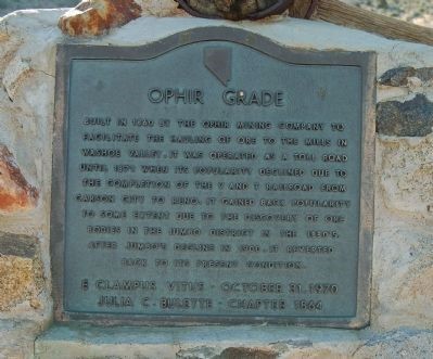
Inscription. Built in 1860 by the Ophir Mining Company to facilitate the hauling of ore to the mills in the Washoe Valley, it was operated as a toll road until 1871 when its popularity declined due to the completion of the V and T Railroad from Carson City to Reno. It gained back popularity to some extent due to the discovery of ore bodies in the Jumbo District in the 1880’s. After Jumbo’s decline in 1900, it reverted back to its present condition.
E Clampus Vitus – October 31, 1970
Julia C. Bulette – Chapter 1864
Marker series. This marker is included in the E Clampus Vitus marker series.
Location. 39° 17.982′ N, 119° 39.265′ W. Marker is in Virginia City, Nevada, in Storey County. Marker is on South C Street (State Highway 341), on the left when traveling north. Marker is in this post office area: Virginia City NV 89440, United States of America.
Originally dedicated October 31, 1970 and later destroyed by lightning, re-dedicated June 26, 1982.
BOB

Bob
Pasadena, Calif. April 8, 1911 · Virginia City, Nev. June 26, 1968
· The Parentheses ·
Young love to the sea. Intense and critical love for place
and people . . . Editor of the Territorial Enterprise wher
he reigned intense and critical . . . “High” Commodore of the
Virginia City Yacht Club . . . To those who loved him,
“A touch of Twain revisiting the Comstock”. His insistence of
placement here of this famous railroad relic . . .
Sail on . . . Rail on plumed warrior . . .
· Bob Richards ·
Julia C. Bulette Chapter, E Clampus Vitus
· September, 1969 ·
Location: N 39° 18.540 W 119° 39.004 ; 11S E 271511 N 4354416
The Nevada Bank of San Francisco

Inscription. Built in 1862-63, this building was first the office of the private bankers Paxton and Thornburgh. After their move to Reese River in 1864-65, it was used sporadically until the Nevada Bank of San Francisco opened January 10, 1876.
Owned by the “Big Four” Mackay, Fair, Flood and O’Brian with Louis McLane. This bank engaged in international financial business for Nevadans for almost twenty years.
While never large, the Nevada Bank was important and successful and when closed in April 1895. The Comstock lost a notable institution.
Julia C. Bulette Chapter, E Clampus Vitus June 24, 1972
Marker series. This marker is included in the E Clampus Vitus marker series.
Location. 39° 18.566′ N, 119° 38.995′ W. Marker is in Virginia City, Nevada, in Storey County. Marker is on C Street (Nevada Route 341) near Taylor Street, on the right when traveling north. Touch for map. Marker is mounted on the wall at entrance to the retail store at north end of building. Marker is in this post office area: Virginia City NV 89440, United States of America.
Big Bonanza
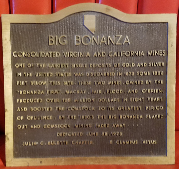
“Consolidated Virginia and California mines. One of the largest single deposits of gold and silver in the United States was discovered in 1873 some 1200 feet below this site. These tow mines owned by the “Bonanza” firm Mackay, Fair, Flood, and O’Brien, produced over 105 million dollars in 8 years and boosted the Comstock to its greatest period of opulence. By the 1880’s the Big Bonanza played out and Comstock mining faded away. Dedicated June 30, 1973, Julia C. Bulette Chapter, E Clampus Vitus.”
Location” Plaque was to be located at site of Con-Virginia Mill near E Street; plaque not displayed.
Odeon Saloon – Billiard Parlour
Dayton Lodge No. 5 I.O.O.F.
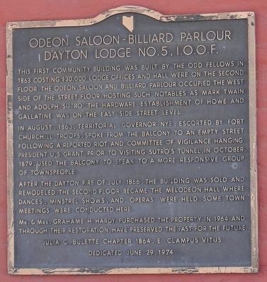
Inscription. The first community building was built by the Odd Fellows in 1863 costing $30,000. Lodge offices and Hall were on the second floor. The Odeon Saloon and Billiard Parlour occupied the west side of the street floor, hosting such notables as Mark Twain and Adolph Sutro. The hardware establishment of Howe and Gallatine was on the east side street level.
In August, 1863, Territorial Governor Nye, escorted by Fort Churchill troops, spoke from the balcony to an empty street following a reported riot, and committee of vigilance hanging. President U.S. Grant, prior to visiting Sutro’s tunnel, in October, 1879, used the balcony to speak to a more responsive group of townspeople.
After the Dayton fire of July, 1866, the building was sold and remodeled. The second floor became the Melodeon Hall where dances, minstrel shows, and operas were held. Some town meetings were conducted here.
Mr. & Mrs. Grahame H. Hardy purchased the property in 1964 and through their restoration, have preserved the past for the future.
Erected 1974 by E Clampus Vitus- Julia C. Bulette Chapter 1864.
Marker series. This marker is included in the E Clampus Vitus marker series.
Location. 39° 14.203′ N, 119° 35.45′
Chief Truckee

Inscription. The legendary Paiute Leader; friend and guide to pioneers; breveted a “Captain” by John C. Fremont; gave his name to a valley, river and town; died near here in 1860.
Dedicated July 20, 1974
By E Clampus Vitus
Julia C. Bulette Chapter 1864
Snowshoe Thompson Chapter 1827
Chief Truckee Chapter 3691
(Total 7382)
Erected 1974 by E Clampus Vitus.
Marker series. This marker is included in the E Clampus Vitus marker series.
Location. 39° 14.149′ N, 119° 35.367′ W. Marker is in Dayton, Nevada, in Lyon County. Marker is on U.S. 50 near Main Street, on the right when traveling north. Touch for map. Marker is at or near this postal address: 120 US 50, Dayton NV 89403, United States of America.
The Great Seal of the State of Nevada
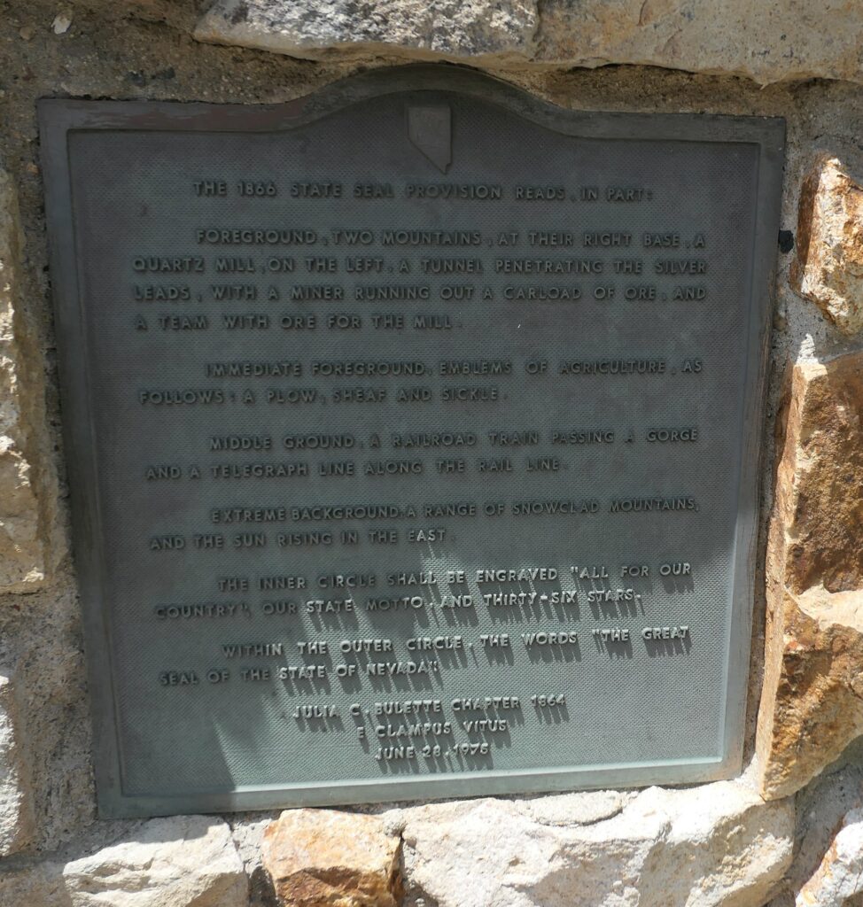
The 1866 State Seal provision reads in part:
‘Foreground, two mountains, a their right base, a quartz mill, on the left, a tunnel penetrating the silver leads, with a miner running out a carload of ore, and a team with ore for the mill.’
‘Immediate foreground, emblems of agriculture, as follows: a plow, sheaf and sickle.’
‘Middle ground, a railroad train passing a gorge and a telegraph line along the rail line.’
‘Extreme background, a range of snow-clad mountains and the rising sun to the east.’
‘Within the outer circle, the words: ‘The Great Seal of Nevada.’ Julia C. Bulette Chapter 1864, E Clampus Vitus, June 28, 1975.”
Location: Gold Hill, Gold Hill Hotel, State Route 80.
Jumbo (West Comstock)


Location: 39° 16.2973’ N, 119° 40.6448’ W, up the Comstock Mining Road from Cemetery Road
Widows and Orphans Abide
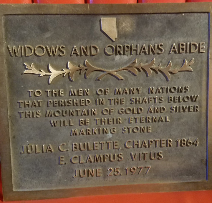
“To the men of many nations that perished in the shafts below, this mountain of gold and silver will be their eternal marking stone. Julia C. Bulette Chapter 1864, E Clampus Vitus, June 28, 1975.”
Location: 39.310783, -119.649549 In front of the Bucket of Blood Saloon, 1 S C St, Virginia City, NV 89440.
Snowshoe Thompson
7/10/1977 with Snowshoe Thompson Chapter 1827. A 20-foot granite shaft located on Highway 88, summit of Carson Pass, with 3 plaques of 20 names each of sponsors.
38°41’43.5″N 119°59’23.4″W
Kirkwood, CA 95646
https://goo.gl/maps/Db5BR3dRYCtSxjk1A

Snowshoe Thom(p)son
(John Tostensen)
A True Pioneer
“…There ought to be a shaft raised to Snow-Shoe Thompson; not of marble; not carved and not planted in the valley, but a rough shaft of basalt or of granite, massive and tall, with top ending roughly, as if broken short, to represent a life which was strong and true to the last. And this should be upreared on the summit of the mountains over which the strong man wandered so many years, as an emblem of that life which was worn out apparently without an object…”
Attributed to: Dan DeQuille, Territorial Enterprise, May 19, 1876.
Dedicated this 10th day of July 1977, as a Founded and Endorsed Bicentennial Project, by the Nevada members of the Ancient and Honorable Order of
E Clampus Vitus

Elko County High School

In 1895, Nevada established the County High School Act. Built in 1896, this was the first school building in Nevada to be constructed under this act. The structure served as the Elko County Library from 1917 to 1974, when the county offices located here.
Erected 1978 by Julia C. Bulette Chapter 1864 E Clampus Vitus.
Marker series. This marker is included in the E Clampus Vitus marker series.
Location. 40° 50.048′ N, 115° 45.789′ W. Marker is in Elko, Nevada, in Elko County. Marker is on Court Street, on the right when traveling west. Marker is at or near this postal address: 569 Court Street, Elko NV 89801, United States of America.
Original Silver Discovery
Fort Homestead, Gold Hill, Nevada

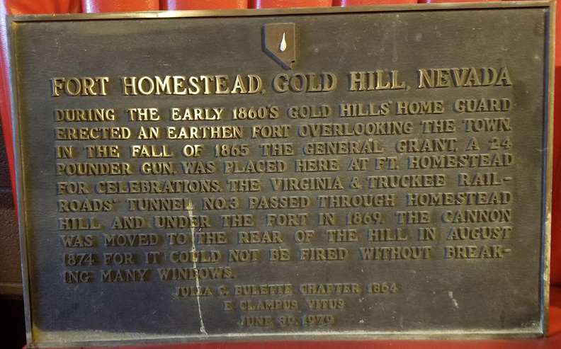
“During the early 1860’s Gold Hill’s Home Guard erected an earthen fort overlooking the town. In the fall of 1865 the General Grant, a 24 pounder gun, was placed here at Ft. Homestead for celeb-rations. The Virginia & Truckee Railroad’s tunnel No. 3 passed through Homestead Hill and under the fort in 1869. The cannon was moved to the rear of the hill in August 1974 for it could not be fired without breaking many windows. Julia C Bulette Chapter 1864, E Clampus Vitus, June 30, 1979.”
Location: reinstalled on Fort Homestead Road, Gold Hill, Nevada. 39.2932673, -119.6554818
Ships of the Nevada Desert
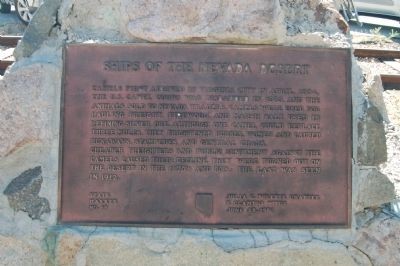
Inscription. Camels first arrived in Virginia City in April, 1964. The U.S. Camel Corps was disbanded in 1863, and the animals sold to Nevada traders. Camels were used for hauling freight, firewood, and marsh salt use in refining silver ore. Although one camel could replace three mules, they frightened horses, women and caused runaways, stampedes, and general chaos. Cheaper freighters and public sentiment against the camels caused their decline. They were turned out on the desert in the 1870’s and 80’s; the last was seen in 1912.
Erected 1980 by Julia C. Bulette Chapter No. 1864, E Clampus Vitus. (Marker Number 69.)
Marker series. This marker is included in the E Clampus Vitus marker series.
Location. 39° 18.66′ N, 119° 38.897′ W. Marker is in Virginia City, Nevada, in Storey County. Marker is at the intersection of E Street and Union Street on E Street. Touch for map. Marker is in this post office area: Virginia City NV 89440, United States of America.
Star City

“Located near the top of 9,835-foot Star Peak, the Star Mining District (some seven miles west of here) was opened in 1861 with the discovery of rich ore in the Sheba mine. Star City developed almost overnight and quickly grew to become the largest community in the area. 1,200 persons were residents here in 1864 when the town boasted of two hotels, three general stores, a Wells Fargo office, a Sunday school, and countless saloons.
“1864-65 were the biggest years for Star City with seven large mining companies in operation, but by 1868 the rich ore ran out and the town declined rapidly. The Sheba mine had produced over $5,000,000 in silver but by 1871 only 78 inhabitants remained and by 1871 Star City was a ghost town. Today all that remains are shadows on the earth and the memory of one of Nevada’s earliest cities. State Historical Marker 231. Sponsor – Julia C Bulette Chapter 1864, E Clampus Vitus, August 30, 1980.”
Location: north of Unionville, Nevada, on State Route 50.
Reunion at Unionville

“Across the road from this site and down about 300 feet was the original Unionville school house. This adobe building, built in 1862, was the first public structure in Humboldt County. Numerous institutions used this school house for their meetings, such as the Union League, Knights of the Golden Circle, Masonic Organization, and the ANCIENT AND HONORABLE ORDER OF E CLAMPUS VITUS. This building was demolished in August, 1871, because of lack of use.
“Exaclty 109 years later members of the ECV gathered here to hold a reunion in commemoration of this prepitious [sic] event. The the rear of this marker, built into the hillside, is Mark Twain’s cabin. Also a member of ECV, he built this cabin in 1861 and lived here before moving on to Virginia City. State Historic Marker 232. Sponsor – Julia C Bulette Chap. 1864, E Clampus Vitus, August 31, 1980.”
Location: Unionville, Nevada.
To The People of Erin
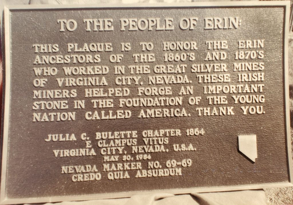

“This plaque is to honor the Erin ancestors of the 1860’s and 1870’s who worked in the great silver mines of Virginia City, Nevada. these Irish miners helped forge an important stone in the foundation of the young nation called America. Thank you. Dedicated May 30, 1984, Julia C. Bulette Chapter 1864, E Clampus Vitus, Nevada Historical Marker 69-69.”
Location: Blarney Castle, City and County of Cork, Ireland, at Blarney Castle Museum.
The Dayton, Sutro, and Carson City Railroad
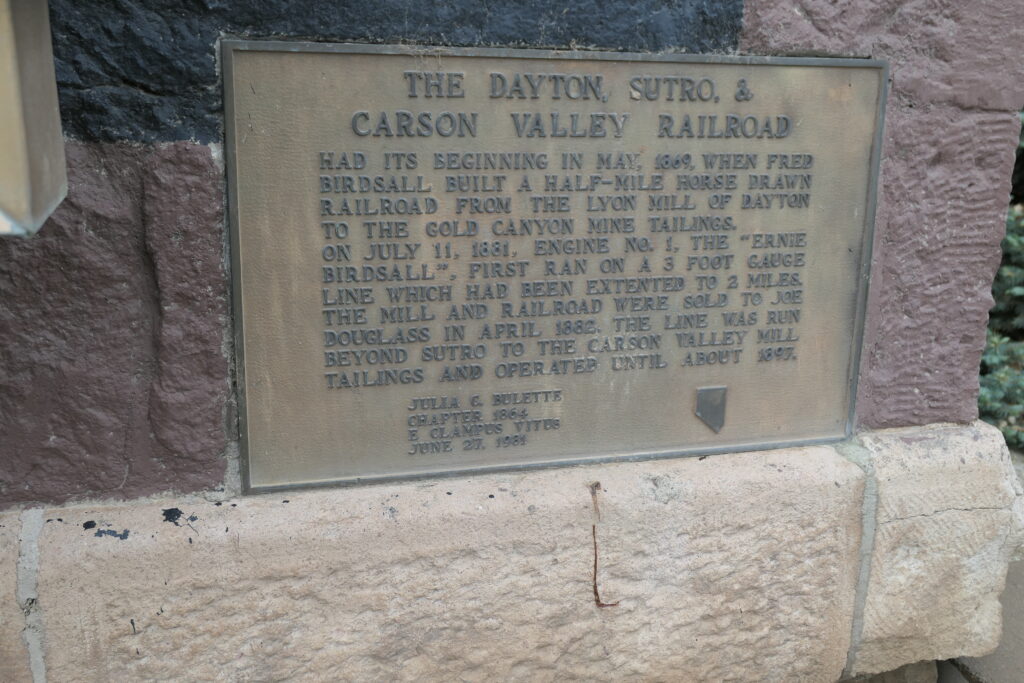
“The Dayton, Sutro, and Carson City Railroad had its beginnings in May 1869, when Fred Birdsall built a half-mile horse drawn railroad from the Lyon Mill of Dayton to the Gold Canyon Mine tailings. On July 11, 1881, Engine No. 1, the ‘Ernie Birdsall’ first ran on a 3 foot gauge line which had been extended to three miles. The mill and railroad were sold to Jom Douglass in April 1882. The line was run beyond Sutro to the Carson Valley Mill tailings and operated until about 1897. Julia C. Bulette Chapter 1864, E Clampus Vitus, June 27, 1981.:
Location: Lyon County Offices Building, Shady Lane and Main Street, Dayton, Nevada.
Lake Tahoe Outlet Works
and Gatekeepers Cabin
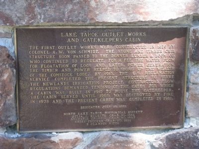
Inscription. The first outlet works were constructed in 1870 by Colonel A.W. Von Schmidt. The stone and timber crib structure soon passed to the Donner Lumber & Boom Co. who continued to regulate, for a fee, the water flow for floatation of logs and, later, power generation. The timber and power helped to shore up the wealth of the Comstock Lode. By 1913, the U.S. Reclamation Service completed the present structure to serve the Newlands Irrigation Project. Contractual flow regulations demanded tending of the gates for which a cabin was built in 1910 to house the gatekeeper. The cabin served until 1968, was destroyed by fire in 1978 and the present cabin was completed in 1981.
Erected 1981 by North Lake Tahoe Historical Society, Julia C. Bulette Chapter No. 1864, Snowshoe Thompson Chapter No. 1827 and Chief Truckee Chapter No. 3691 – E Clampus Vitus. (Marker Number 797.)
Marker series. This marker is included in the E Clampus Vitus marker series.
Location. 39° 9.997′ N, 120° 8.607′ W. Marker is in Tahoe City, California, in Placer County. Marker can be reached from West Lake Boulevard (State Highway 89) west of Highway 28, on the right when traveling east. Marker is at or near this postal address: 130 West Lake Boulevard, Tahoe City CA 96145, United States of America.
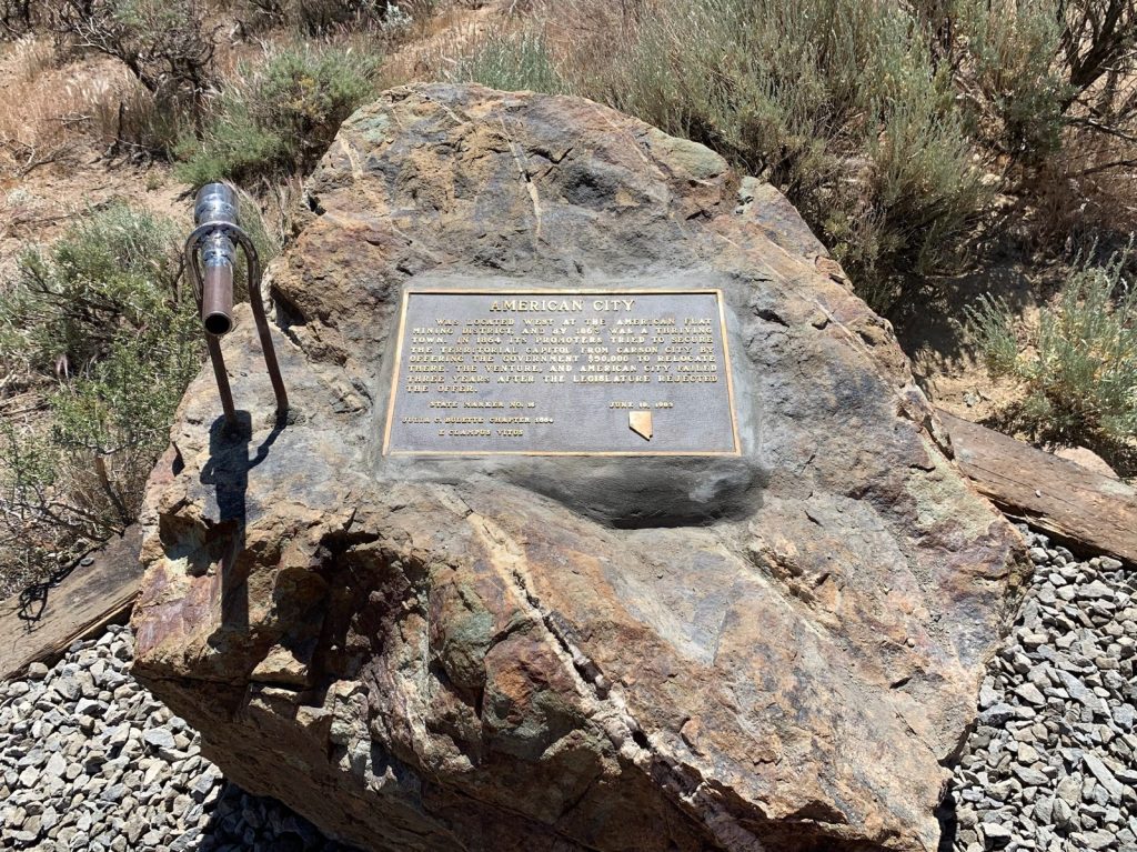
American City

“American City was located west at the American Flat mining district, and by 1863 was a thriving town. In 1864 its promoters tried to secure the territorial capitol from Carson City by offering the government $50,000 to relocate there. The venture, and American City failed three years later after the legislature rejected the offer. State Marker No. 16, Julia C. Bulette Chapter, E Clampus Vitus June 18, 1983.”
Location: 39° 16.2973’ N, 119° 40.6448’ W, up the Comstock Mining Road from Cemetery Road
“Brunswick Ledge”
Monte Cristo Lode / Occidental Lode
Silver Star Mining District

A separate but similar parallel ore body, 1 ¼ miles east of the Comstock Lode and 2 ¼ miles long, located 1863 by crew of the Occidental Mine at the south end and later by the Monte Cristo Mine on north. In 1872 Sutro Tunnel crews cut a 100 ft. wide ledge 1361 feet under the St. John property and named the rich vein “Brunswick”, possibly to honor the exquisite saloon back bars and billiard tables of that era.
Several major Comstock mines extended to the ledge in 1895. Peak production years were 1896-1914 with two million dollars of ore removed.
Dedicated June 23, 1986
Julia C. Bulette Chapter No.1864
E Clampus Vitus
Location: 39° 16.2973’ N, 119° 40.6448’ W, up the Comstock Mining Road from Cemetery Road.
Site of International Hotels
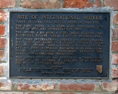
Inscription. Three International Hotels stood on this lot:
The first hotel, a 14 room wood structure, was built in 1860 and dismantled in 1863.
The second, a 100 room, 4 story brick building, was destroyed by the “Great Fire” of October 1875.
The third International opened its doors March, 1877, with 160 rooms on 6 floors, complete with hot/cold running water, steam heat, gas lighting, and the first hydraulic elevator in Nevada. Local notables and visiting dignitaries utilized the grand restaurant/bar facilities.
This superb hostelry was reduced to a “magnificent ruin” by fire December 12, 1914, not to be rebuilt due to the Comstock decline.
Erected 1985 by Julia C. Bulette, Chapter 1864 E Clampus Vitus and the Bucket of Blood Saloon, Virginia City.
Marker series. This marker is included in the E Clampus Vitus marker series.
Location. 39° 18.651′ N, 119° 38.972′ W. Marker is in Virginia City, Nevada, in Storey County. Marker is at the intersection of South C Street (Nevada Route 341) and Union Street, on the right when traveling south on South C Street. Touch for map. Marker is in this post office area: Virginia City NV 89440, United States of America.
The Union Brewery

“Beer was not forgotten, and six breweries could scarcely supply the people with beer, for Virginia City has a dry climate.
“Originally located at 40 North C Street and destroyed by the Fire of 1865, the Union Brewery moved to its present location in 1866.
Beer was brewed in the basement, and the saloon was situated on the first floor.
Fire once again destroyed the building in 1875, and was re-built in 1876.
Since its conception, prohibition was the only evil that interrupted sale, making the Union Brewery one of the longest continuous operating saloons in Virginia City.
Dedicated to the memory of Duff Chapman
Julia C. Bulette Chapter 1864
E Clampus Vitus
June 28, 1986
Marker series. This marker is included in the E Clampus Vitus marker series.
Location. 39° 18.681′ N, 119° 38.95′ W. Marker is in Virginia City, Nevada, in Storey County. Marker is on C North Street (State Highway 341), on the right when traveling north. Touch for map. Marker is at or near this postal address: 28 North C Street, Virginia City NV 89440, United States of America.
Rochester
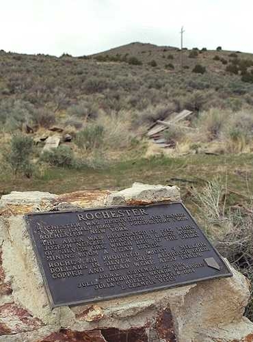
“Rochester was discovered and named in the early 1960’s by prospectors from Rochester, New York. The area was relocated in 1912 when Joseph Nenzel discovered large bodies of silver ore which lead to the great mining boom a year later. Rochester produced about 9 million dollars in silver ores, although gold, copper and lead were also taken. J.U.N.K September 20, 1986, Julia’s Unequivocal Nevada Klampouts, Julia C Bulette Chapter 1864, E Clampus Vitus.”
Location: 40.2888431,-118.1808016. Rochester, Nevada; main road through lower Rochester, now a ghost town.
Philip Deidesheimer
1832-1916
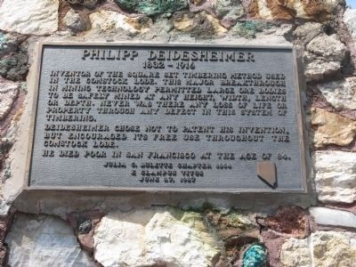
Inscription: Inventor of the Square Set Timbering method used in the Comstock Lode. This major breakthrough in mining technology permitted large ore bodies to be safely mined at any height, width, length or depth. Never was there any loss of life or property through any defect in this system of timbering.
Deidesheimer chose not to patent his invention, but encouraged its free use throughout the Comstock Lode. He died poor in San Francisco at the age of 84.
Julia C. Bulette Chapter 1864
E Clampus Vitus
June 27, 1987
Location. N 39° 18.618, W 119° 38.972; 11S E 271561 N 4354559
Quick Description: This historical marker stands in the center of town on C Street (Nevada Route 341), on a large, four-sided, composite rock base monument, with informative plaques on each side commemorating historical events and people of Virginia City, Nevada.
Pierce Station

“Established by Zadok Pierce in 1875 as a hotel, grocery, and feed store. It was sold in 1903 to the Reading Bros., of Bodie, who re-named it the W.E. Reading General Merchandise. Later on in 1945, Perry & Gerri Aikens acquired it and gave it its present name: The Heydey Inn. In 1980 W. Carlson & J. Ithurburu bought it from E. Groso, remodeled the interior, leaving the exterior in its original condition. Reopened for business in January 1983. Dedicated this 14th day of May 5993 (1988) by: Bodie Chapter No. 64, Julia C. Bulette Chapter 1864, Snowshoe Thomson Chapter 1827 of E Clampus Vitus.”
Location: 38° 45.084′ N, 119° 22.205′ W. Marker is on Ruta Estatal de Nevada/Wellington Cutoff (Nevada Route 829), on the right when traveling east. HMDB map. Marker is at or near 2771 Wellington Cutoff, Smith NV 89430, United States of America. Google map. Pierce Building, Wellington, Nevada.
Frank Bell
1840 – 1927

Inscription. Early pioneer of both the telegraph and telephone. He was builder of the first telegraph lines across the Sierra’s from Placerville to Genoa then on to Virginia City. He also had the distinction of telegraphing Nevada’s Constitution to President Lincoln prior to Nevada becoming a state in 1864.
Frank Bell served as the sixth governor of Nevada from September – December 1890.
Julia C. Bulette Chapter 1864
E Clampus Vitus
June 18, 1988
Erected 1988 by Julia C Bulette Chapter, E Clampus Vitus.
Marker series. This marker is included in the E Clampus Vitus marker series.
Location. 39° 18.418′ N, 119° 39.054′ W. Marker is in Virginia City, Nevada, in Storey County. Marker is on C Street (Nevada Route 341), on the right when traveling south. Marker is mounted on the front of the building. Marker is at or near this postal address: 372 C Street, Virginia City NV 89440, United States of America.
Nevada Brewery


“The earliest known breweries in Virginia City were the Nevada Brewery and the Virginia Brewery both founded between 1860 and 1861. The Nevada Brewery House on this site was not only the first, but the last to cease operations, closing its doors in 1913. Virginia City was blessed with eleven breweries including the Philadelphia, St. Louis, Union, Washoe, California, Carson, Eagle, Pacific, and Washington, all of which contributed to its famous hard drinking history. Dedicated June 26, 1971, Julia Q Bulette 1864 E Clampus Vitus.”
Location: 39° 18′ 41.89″ N, 119° 38′ 32.60″ W At 355 Mill Street, near intersection with P Street, in Virginia City, NV.
Plaque was originally on display inside the Nevada Brewery building. It was inside the brewery on Mill Road (6 Mile Canyon) – unmounted. In 1983 fire destroyed the building. The plaque was retrieved from the ashes. Re-mounted in 6027 (2022 CE).
100th Anniversary of the Salvation Army

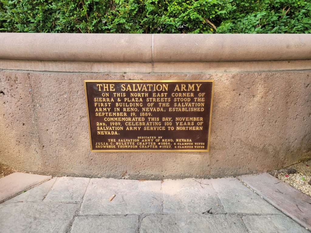
Re-Hung on or about Flag Day, 6028 (2023 C.E.) Location: 39.528643, -119.815370
McCarran Ranch
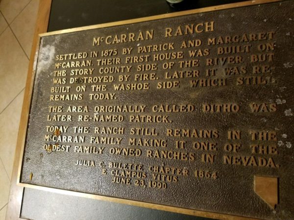
Settled in 1875 by Patrick and Margaret McCarran. Their first house was built on the Story [sic] County side of the river but was destroyed by fire. later it was re-built on the Washoe County side which still remains today.
The area originally called Ditho was later re-named Patrick.
Today the ranch still remains in the McCarran family making it one of the oldest family owner ranches in Nevada.
Julia C. Bulette Chapter 1864
E Clampus Vitus
June 23, 1990
Location: The plaque is now leaning up against a building at or near this location: 39.549035, -119.572582
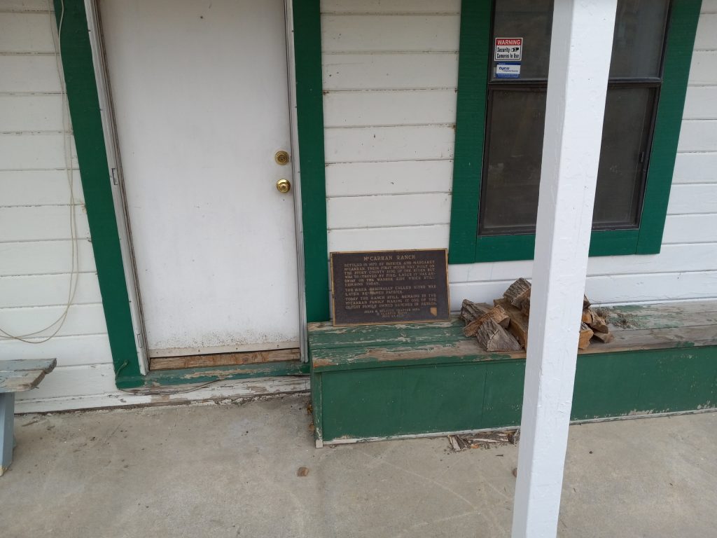 McCarran Preserve | 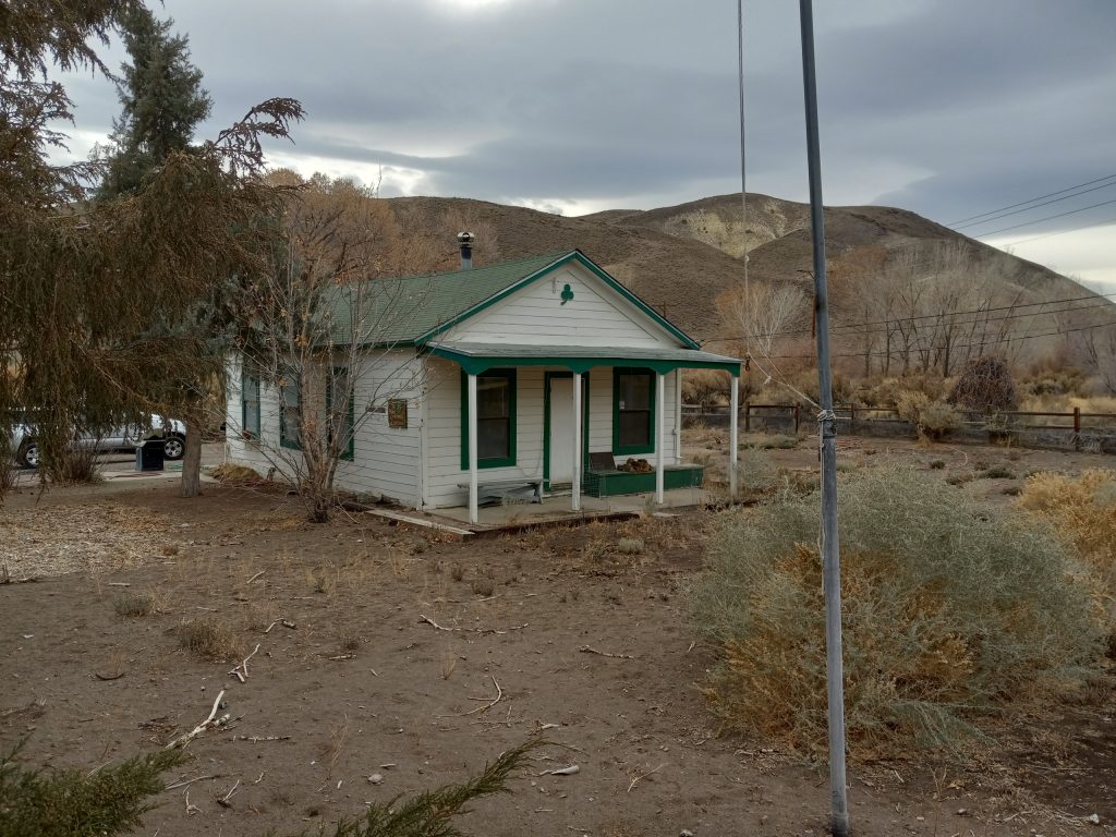 Private Property |
Hoye’s Store

The Hoye’s Store building, which became know as the Wellington Mercantile, was destroyed by fore on September 13, 2000. Investigators said it was caused by trash ignited by a water heater pilot light. The Mercantile was known as a “shrine to small town general stores” with galvanized tubs hanging from the rafters and Norma’s homemade apple pie served with lunch. The plaque was installed at the CG Bar across the street from the original location on July 27, 2018, so that Clampers can have a drink destination in the Smith Valley.
Location: 2822 NV-208, Wellington, NV 89444
38.7567337, -119.3771631
The Crystal Bar

Inscription. The doors were first opened for business in 1871 by original owner Grant Israel. In the early 1880’s Con Sheen became the second owner. In 1909 William H. Marks became the third owner. The bar is still in the family as William L. And Margaret Marks have owned this establishment since 1955. During Prohibition Era it was an ice cream parlor and a “speak easy.” The original crystal chandeliers are from France and arrived by ship in San Francisco and railroad to here. The photos on the walls are all originals as is the back bar and all the hardware. The crystal goblets and glasses are very unique indeed and most of them are irreplaceable. The bar has been in continuous service from 1871 up until today.
Julia C. Bulette Chapter 1864
E Clampus Vitus
June 27, 1992
Erected 1992 by Julia C. Bulette Chapter 1864 E Clampus Vitus.
Marker series. This marker is included in the E Clampus Vitus marker series.
Location. 39° 18.58′ N, 119° 39.009′ W. Marker is in Virginia City, Nevada, in Storey County. Marker can be reached from the intersection of C Street and Taylor Street. Touch for map. Marker is now located on the south wall of the Crystal Bar building (now the Virginia City Visitor Center).
Mary Jane Simpson
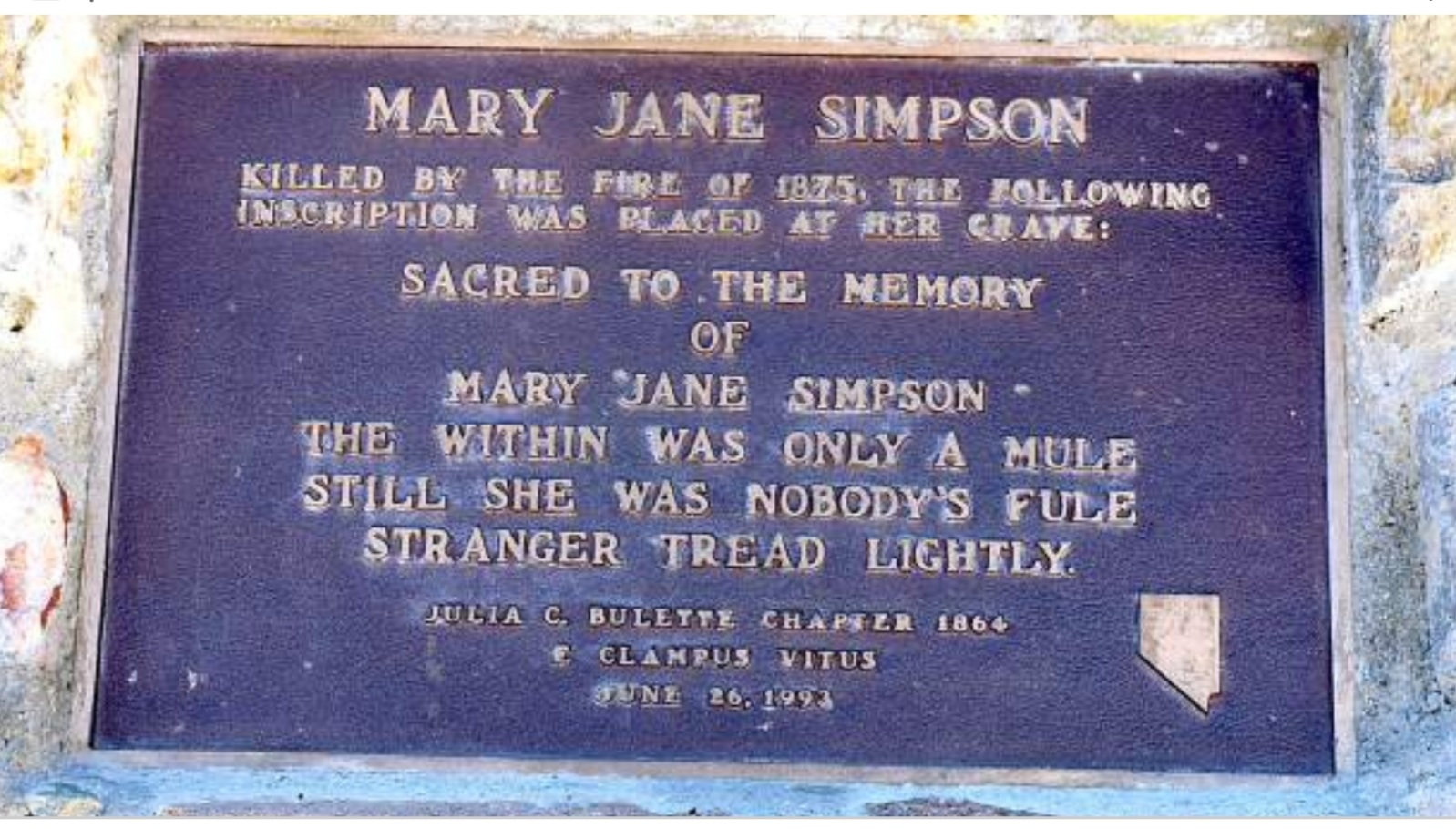
Killed by the fire of 1875. The following inscription was placed at her grave:
Sacred to the memory of Mary Jane Simpson
The within was only a mule
Still she was nobody’s fule
Stranger, tread lightly.
Julia C. Bulette Chapter 1864
E Clampus Vitus
June 26, 1993
Location: N 39° 18.100 W 119° 40.000 In the Boothill Cemetery of Virginia City, NV
William Wright aka Dan De Quille
May 9, 1829 – March 16, 1898
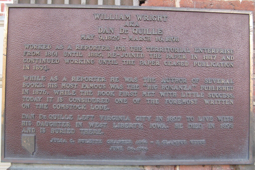
Inscription.
Worked as a reporter for the Territorial Enterprise from 1861 until 1885, re-joined the paper in 1887 and continued working until the paper ceased operation.
While as a reporter he was the author of several books. His most famous was the “Big Bonanza” published in 1876. While the book first met with little success today it is considered one of the foremost written on the Comstock Lode.
Dan De Quille left Virginia City in 1897 to live with his daughter in West Liberty, Iowa. He died in 1898 and is buried there.
Julia C. Bulette Chapter 1864, E Clampus Vitus
June 24, 1994
Marker series. This marker is included in the E Clampus Vitus marker series.
Location. 39° 18.606′ N, 119° 38.981′ W. Marker is in Virginia City, Nevada, in Storey County. Marker is on C Street (Nevada Route 341), on the left when traveling north. Touch for map. Marker is mounted on the front of the Territorial Enterprise – Mark Twain Museum Building. Marker is at or near this postal address: 53 South C Street, Virginia City NV 89440, United States of America.
E Clampus Vitus Building
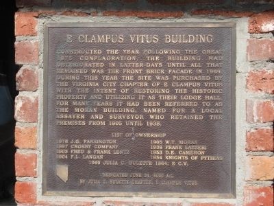
Inscription. Constructed the year following the great 1875 conflagration, the building had deteriorated in latter-days until all that remained was the front brick façade in 1969. During this year the site was purchased by the Virginia City Chapter of E Clampus Vitus with the intent of restoring the historic property and utilizing it as their lodge hall. For many years it had been referred to as The Moran Building, named for a local assayer and surveyor who retained the premises from 1905 until 1938.
List of Ownership
[Column 1:]
1876 – J.G. Harrington ● 1897 – Crosby Company ● 1903 – Fred & Frank Lentz ● 1904 – F.L. Langan
Column 2:]
1905 – W.T. Moran ● 1938 – Frank Lazzeri ● 1953 – D.E. Comeron ● 1954 – Knight of Pythias ●
1969 – Julia C. Bulette 1864, E.C.V.
Dedicated June 24, 6000 A.L.
By Julia C. Bulette Chapter E. Clampus Vitus
Erected 1995 by Julia C. Bulette Chapter 1864, E Clampus Vitus.
Marker series. This marker is included in the E Clampus Vitus marker series.
Location. 39° 18.69′ N, 119° 39′ W.
E Clampus Vitus Building Marker
Marker is in Virginia City, Nevada, in Storey County. Marker is on B Street near Union Street, on the right when traveling south. Marker is in this post office area: Virginia City NV 89440, United States of America.
601’s
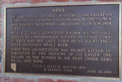
Inscription. In the spring of 1871, a secret organization comprised of leading citizens and business men, was formed to combat lawlessness in Virginia City.
This vigilance committee, known as the 601’s, served to undesirables, notices to leave town. If they had not left town by 24 hours, they were severely dealt with.
Since this organization was secret, little information to the meaning of 601 exists. One theory to the number is: Six Feet Under, Zero Trial, One Rope.
Erected 1996 by Julia C. Bulette Chapter 1864 E Clampus Vitus.
Marker series. This marker is included in the E Clampus Vitus marker series.
Location. 39° 18.684′ N, 119° 38.998′ W. Marker is in Virginia City, Nevada, in Storey County. Marker is on North B Street, on the right when traveling north. Touch for map. Marker is at or near this postal address: 34 North B Street, Virginia City NV 89440, United States of America
Old County Courthouse – Hawthorne, NV

On July 1, 1883 the county seat of Esmeralda County moved from Aurora to Hawthorne. A court house was needed, so a contract to build it for $29125 was awarded. On August 16, 1883 construction began. Corruption and collusion between the contractor George W. Babcock, and political officials are revealed by a grand jury. Despite the wrong doings, in February of 1884 the building was opened and continued as a county entity until May 1907, when the county seat moved to Goldfield. On February 11, 1911 Esmeralda County was split and Mineral County was created. Again, it became the center of county business until 1973, when a modern facility replaced it.
1996 by Walker Lake Posse #6000
Outpost of Julia C. Bulette #1864 E Clampus Vitus
Marker is located in front of the former courthouse which is surrounded by a chain link fence. This building was officially registered in the National Register of Historic Places in January of 1982. A NRHP plaque is mounted on the building and placed in September of 1983.
N 38° 31.512 W 118° 37.602
11S E 358200 N 4265343
Virginia and Truckee Railroad
“Do it at once”

Inscription. “Do it at once” was the order given to I. E. James by William Sharron to build the V & T Railroad.
Construction to Carson City was completed in November 1869. By November 1871, Reno was connected to Carson City thus establishing a shipping route from the Comstock to the Union Pacific. The V & T was to become known as “the richest railroad in the world.”
On May 31, 1950 the V & T ceased operations.
Erected 1997 by Julia C. Bulette Chapter No. 1864, E Clampus Vitus.
Marker series. This marker is included in the E Clampus Vitus marker series.
Location. 39° 18.661′ N, 119° 38.898′ W. Marker is in Virginia City, Nevada, in Storey County. Marker is at the intersection of E Street and Union Street on E Street. Touch for map. Marker is in this post office area: Virginia City NV 89440, United States of America.
The Pillar of Light
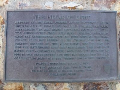
Inscription. Debuted in the later forties at the Hawthorne Club located at the corner of 5th and E Street, the main intersection of all roads entering Hawthorne. This was a sign of the times with neon lighting. It brightened the intersection with its huge display. The Hawthorne Club was coined as the “Bright Spot on the Corner” because of this magnificent sign. In June of 1996, the Hawthorne Club was demolished. The sign was saved, then modernized with donations. In December of 1996 it was resurrected and now has become the “Pillar of Light” and again it is the “Bright Spot on the Corner!”
Erected 1997 by Walker Lake Posse #6000 Oupost of Julia C. Bulette Chapter #1864 E. Clampus Vitus.
Marker series. This marker is included in the E Clampus Vitus marker series.
Location. 38° 31.996′ N, 118° 37.532′ W. Marker is in Hawthorne, Nevada, in Mineral County. Marker is at the intersection of U.S. 95A and Freedom Road (Nevada Route 362), on the right when traveling south on U.S. 95A. Easy to find driving on US 95 from the north, look a little harder coming in from the south. Marker is in this post office area: Hawthorne NV 89415, United States of America.
William Sharon
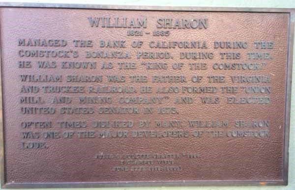
William Sharon
1821-1885
Managed the Bank of California during the Comstock’s Bonanza period. During this time, he was known as the “King of the Comstock.”
William Sharon was the father of the Virginia and Truckee Railroad. He also formed the “Union Mill and Mining Company” and was elected United States Senator in 1875.
Often times disliked by many, William Sharon was one of the major developers of the Comstock Lode.
Julia C. Bulette Chapter #1863
E Clampus Vitus
June 27th 1998 (6003)
Location: N 39° 18.572 W 119° 39.002 ; 11S E 271515 N 4354475 ; Bonanza Saloon building in Virginia City, NV.
Rhodes Marsh
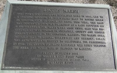
Inscription. Salt pools discovered and developed here in 1862, led to a thriving business by delivering salt to mining mills in Virginia City by camel. Up until this time, the salt was purchased from San Francisco at a rate between 120 & 180 dollars a ton. Sales were good until salt was discovered at Sand Springs in Churchill County and Rhodes couldn’t compete in the Comstock market. The Marsh still supplied salt to Aurora Belleville and Belmont. Borax was also mined and shipped to California for processing. In 1882, the Carson Colorado Railroad was built through the area and moved tons of product to market.
Plaque Dedicated 1998
by Walker Lake Posse #6000
Outpost of Julia C. Bulette Chapter #1864
E Clampus Vitus
Location. 38° 16.277′ N, 118° 5.791′ W. Marker is near Mina, Nevada, in Mineral County. Marker is on U.S. 95 north of County Route 360, on the right when traveling north. Touch for map. Marker is in this post office area: Mina NV 89422, United States of America.
The Old Town of Dayton
Cousin Jack
As the easy to mine placer deposits disappeared, deep underground mining also known as hard rock mining posed new challenges and dan-gers. Immigrant coal miners from Cornwall, England and Ireland were very much in demand for their experience and skill with this type of mining. They were a great help teaching American miners how to hard rock mine. Mine foremen often heard “me cousin Jacks, just over from the old country and he needs job” In this way the Irish and Cornish miners came to be known as “Cousin Jacks.” Their contribution to the Comstock and mining here, in general, was substantial.
Julia C. Bulette Chapter 1864
E Clampus Vitus
June 26, 1999
Location: Odeon Hall, Dayton, Nevada
Gold Hill Cemetery
Inscription: Established before Nevada became a state, the historic graveyards of Gold Hill contained four distinct sections representing the F&A Ma-sons, the Oddfellows, the Catholics and the general populace of Gold Hill. One of the largest funerals in 1887 was over a mile long and con-sisted of 1,300 people and 72 carriages. Fires have destroyed what was once the largest concentration of Victorian markers. These outdoor stone museums are the visual heart of Gold Hill and reflect the moral social and cultural character of those individuals whose lives and ac-tivities shaped the history of the American West.
Dedicated June 24, 2000-6005
Julia C. Bulette Chapter 1864
E Clampus Vitus
Location: Gold Hill Cemetery, Gold Hill, Nevada
The Old Globe Saloon

Inscription: Opened in 1875 on Carson St by Andrew and Henry Robert, French Canadian brothers. The saloon was closed by prohibition in 1918. In 1951 Bob Golightly, Andrew’s grandson asked Virgil Buchhianri to reopen the Old Globe.
In 1971 the saloon was rebuilt on Curry St, it’s current location The building was designed by Hector Puccinelli, former chief bridge engineer, Nevada highway department. The original Carson St saloon was replicated, also incorporating its old stone ice house that was built in 1890.
In memory of Virgil Bucchianeri Sr., 1901-1993
Proprietor 1951-1993
Dedicated July 20, 2001
Julia C Bulette Chapter 1864
E Clampus Vitus
Location: N 39° 09.970 W 119° 46.065 ; 11S E 260878 N 4338866
Blackwell Ponds


Inscription: In 1902 Marion Jefferson Blackwell purchased 360 acres from the state of Nevada, 556 acres of adjoining land from Sweeney’s Hot Springs and a lot with a house. He raised carp and catfish to sell commercially, also hay and horses. Neighbors used the ponds for swimming and ice skating. Born 1847 in Happ County, Georgia he married Nancy Amna Mayes in 1866. While living in Jamestown, California his wife died. He moved the family to Carson Valley near Genoa in 1895. He married Martha “Mattie” H. Willey in Yerington in 1899, then moved to Eagle Valley in 1902. He resided here till his death in 1914. His descendants continue to live in the area.
E Clampus Vitus Chapters
Julia C. Bulette – Snowshoe Thompson – Chief Truckee
October 27, 2001
Location: 39° 10.896′ N, 119° 44.848′ W. Marker is in Carson City, Nevada. Marker is on Spooner Drive near Windridge Drive, on the right when traveling west.
Pony Express Route

Inscription: Along this ridge was the trail of the P/X from St. Joseph, Missouri to Sacramento / San Francisco, California and return. This segment was from Hall’s Station (Dayton) to Carson City P/X Office on the west side of Carson St. just north of 5th Street. The P/X run ended with the comple-tion of the transcontinental telegraph, October 24, 1861; However, it helped preserve the Western Territories for the Union during the Civil War. Near this monument stood later railroad facilities of the Virginia & Truckee and Carson & Colorado Railroads abandoned in 1939. 1980’s commercial development has covered the site.
Dedicated June 29, 2002 (6007)
Mound House, Nevada
Julia C. Bulette Chapter 1864
E Clampus Vitus
Location: Moonlite Road, Moundhouse, Nevada. 39°12’60.0″N 119°40’21.8″W ( 39.216657, -119.672734)
America’s First Transcontinental Highway
Inscription. The Lincoln Highway was conceived and promoted by industrialists who were determined to act on the concept of creating one transcontinental highway from amongst the various and fragmented paths, trails and city streets. The LH (1913 -1927) brought notoriety and some prosperity to rural Nevada towns along its path.
Farm District Road from Fernley toward Hazen was incorporated into the Lincoln Highway. The LH served until the Federal Highway System was developed and continued to be promoted by the towns along its route through the 1930’s. Dedicated May 11, 2002 Nevada-Sierra Chapter, Lincoln Highway Association Chief Truckee, Snowshoe Thompson & Julia C. Bulette Chpts. E Clampus Vitus Fernley Preservation Society
Erected 2002 by Nevada-Sierra Chapter, Lincoln Highway Association, Julia C. Bulette Chapter E Clampus Vitus and Fernley Preservation Society.
Marker series. This marker is included in the E Clampus Vitus, and the Lincoln Highway marker series.
Location. 39° 35.556′ N, 119° 13.611′ W. Marker is near Fernley, Nevada, in Lyon County. Marker is on Farm District Road 0.6 miles south of Farm District Road (Alternate U.S. 50), on the left when traveling south.
St. Mary Louise Hospital
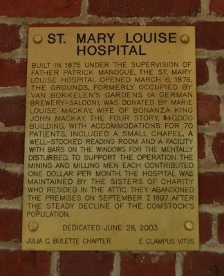
Inscription. Built in 1875 under the supervision of Father Patrick Manogue, the St. Mary Louise Hospital opened March 6, 1876. The grounds, formerly occupied by Van Bokkelen’s Garden (A German brewery-saloon), was donated by Marie Louise Mackay, wife of Bonanza King John Mackay. The four story, $40,000 building, with accommodations for 70 patients, included a small chapel, a well-stocked reading room and a facility with bars on the windows for the mentally disturbed. To support the operation the mining and milling men each contributed one dollar per month. The hospital was maintained by the Sisters of Charity who resided in the attic. They abandoned the premises on September 7, 1897 after the steady decline of the Comstock’s population.
Erected 2003 by Julia C. Bulette Chapter No. 1864, E Clampus Vitus,.
Marker series. This marker is included in the E Clampus Vitus marker series.
Location. 39° 18.539′ N, 119° 38.434′ W. Marker is in Virginia City, Nevada, in Storey County. Marker is on R Street. Touch for map. The entrance to St. Mary’s Art Center is on R Street near the intersection with Union Street. Marker is at or near this postal address: 55 North R Street, Virginia City NV 89440, United States of America.
The Great Fire of 1875
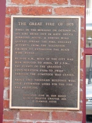
Inscription. Early in the morning on October 26, 1875 fire broke out in Kate Shea’s Boarding House. A strong wind quickly spread the fire. Gallant attempts from the volunteer firemen to extinguish the blaze were futile.
By 11:00 A.M., most of the city had been reduced to ashes. By 2 P.M., the flames of the greatest conflagration ever to sweep through the Comstock had ceased.
About two thousand buildings were lost. Estimated loses for the fire was $10,000,000.
Dedicated June 26, 2004 (6009)
Julia C. Bulette Chapter 1864
E Clampus Vitus
Erected 2004 by Julia C. Bulette Chapter 1864, E Clampus Vitus.
Marker series. This marker is included in the E Clampus Vitus marker series.
Location. 39° 18.54′ N, 119° 39′ W. Marker is in Virginia City, Nevada, in Storey County. Marker is on C Street (Nevada Route 341), on the right when traveling north. Touch for map. Building is located Between Washington Street and Taylor Street. Marker is in this post office area: Virginia City NV 89440, United States of America.
Founders of Julia C. Bulette Chapter
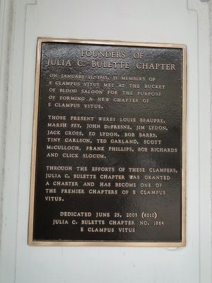
On January 11, 1963, 13 members of E Clampus Vitus met at the Bucket of Blood Saloon for the purpose of forming a new chapter of E Clampus Vitus.
Those present were: Louie Beaupre, Marsh Fey, John Dufresne, Jim Lydon, Jack Cross, Ed Lydon, Bob Barry, Tiny Carlson, Ted Garland, Scott McCulloch, Frank Phillips, Bob Richards and Click Slocum.
Through the efforts of these Clampers, Julia C. Bulette Chapter was granted a Charter and has become one of the premier chapters of E Clampus Vitus.
Erected 2005 by Julia C. Bulette Chapter No. 1864 E Clampus Vitus.
Marker series. This marker is included in the E Clampus Vitus marker series.
Location. 39° 18.637′ N, 119° 38.97′ W. Marker is in Virginia City, Nevada, in Storey County. Marker is at the intersection of C Street (Nevada Route 341) and Union Street, on the right when traveling north on C Street. Marker is at or near this postal address: 1 South C Street, Virginia City NV 89440, United States of America.
Alfred R. Doten
July 21, 1829 – November 12, 1903

Inscription: Alf Doten sailed around the “horn” in 1849, arriving in Nevada in 1863; he is not only famous for being the editor and publisher of the Gold Hill News, but also for his historic daily journal entries from 1849 to 1903.
Dedicated June 24, 2006
Julia C. Bulette Chapter 1864
E Clampus Vitus
Location: supposedly at Hotel Gold Hill, Gold Hill, NV – but nope, it’s at the hall. El Jefe Grande worked up some language about Al and his widder for a complementary plaque to accompany this original on a monument at Hillside Cemetery in Reno. It definitely does not read like a book report. Stay tuned for progress. (June 18, 6028).
The Glory of Solidarity and Fraternity
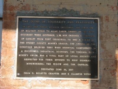
Inscription. In Sept. 1864, while Atlanta smoldered, the first use of military force to allay labor unrest in the West occurred when Governor J. W. Nye ordered 2 companies of Calvary from Fort Churchill to end a strike by The Story County Miner’s League. The Unions of the Comstock believed they were essential components in a successful industrial economy. The Virginia City Miner’s Union was a vital part of local society and respected for their efforts to help disabled mineworkers, the widow and the orphan.
Dedicated June 30, 2007
Julia C. Bulette Chapter 1864 E Clampus Vitus
Erected 2007 by Julia C. Bulette Chapter 1864 E Clampus Vitus.
Marker series. This marker is included in the E Clampus Vitus marker series.
Location. 39° 18.69′ N, 119° 39′ W. 36 B Street near Union Street, Virginia City NV 89440, Storey County, United States of America, on the right when traveling south. Touch for map. Marker is mounted on the front of the Miners Union Hall Building.
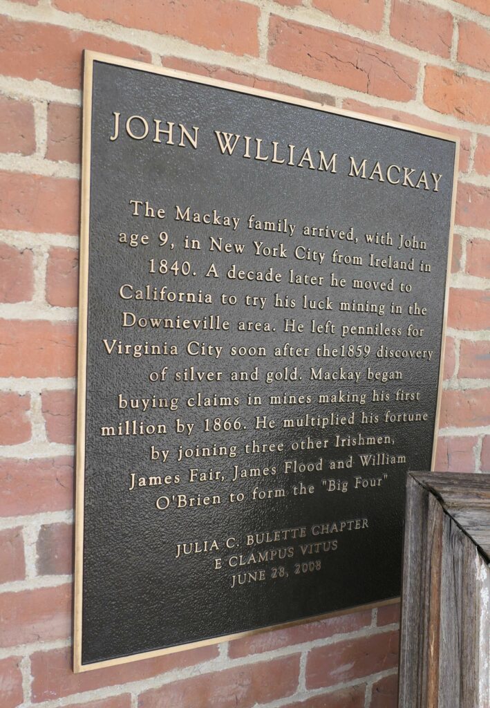
John William Mackay
Location: Mackay Mansion Museum, 291 S D St, Virginia City, NV 89440
The Tonopah Mining Boom
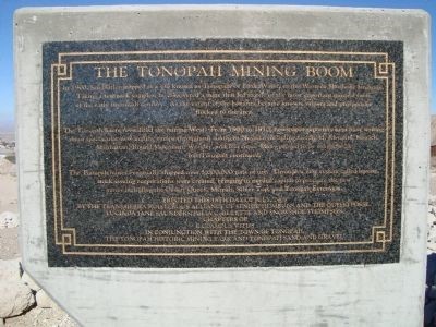
Inscription. In 1900. Jim Butler stopped at a site known as Tonapah, or Little Water, in the Western Shoshone language. Taking a few rock samples, he discovered a mine that led to one of the most important mineral finds of the early twentieth century. As the extent of the bonanza became known, miners and prospectors flocked to the area.
The Tonopah boom revitalized the mining West. From 1900 to 1910, newspaper reporters kept busy writing about spectacular new mining camps throughout southern Nevada, including Goldfield, Rhyolite, Kawich, Manhattan, Round Mountain, Wonder, and Fairview. Many proved to be exaggerated but Tonopah continued.
The Tonopah mines eventually shipped over 5,000,000 tons of ore. Through a new system called leasing, stock issuing corporations were created, bringing in needed capital to promote the new mines including the Desert Queen, Mizpah, Silver Top, and Tonopah Extension.
Erected this 18th day of July, 2009 by the Transsierra Roisterous Alliance of Senior Humbugs and the Queho Posse. Lucinda Jane Saunders, Julia C. Bulette and Snowhoe Thompson Chapters of E. Clampus Vitus in conjunction with the Town of Tonopah, The Tonapah Historical Mining Park and Tonopah Sand and Gravel.
Erected 2009 by E Clampus Vitus/Tonopah Historic Mining Park.
Marker series. This marker is included in the E Clampus Vitus marker series.
Location. 38° 4.183′ N, 117° 13.556′ W. Marker is in Tonopah, Nevada, in Nye County. Marker can be reached from McCulloch Avenue. Touch for map. This marker is located in the Tonopah Historic Mining Park, behind the Visitor’s Center next to the picnic tables. Marker is at or near this postal address: 520 McCullock Avenue, Tonopah NV 89049, United States of America.
Virginia City
Inscription.
[Located in the center of town is a monument on which there is mounted six markers commemorating historical events and people of Virginia City]
West Side – Front of Monument:
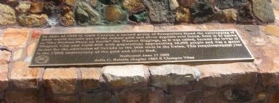
In June of 1859 in Gold Canyon, a second group of Prospectors found the outcropping of what would become one of the richest gold and silver deposits ever found. Soon to be known as “the Richest Place on Earth” the Washoe Diggings, as it was called, became the towns of Silver City and Gold Hill with populations approaching 28,000 people and was a major factor for the admission of Nevada as the 36th state in the Union. This sesquicentennial year is the 150th anniversary of the gold and silver find.
Dedicated June 27, 2009
Julia C. Bulette chapter 1864 E Clampus Vitus
Location: N 39° 18.622, W 119° 38.972; 11S E 271561 N 4354566
Old Virginny
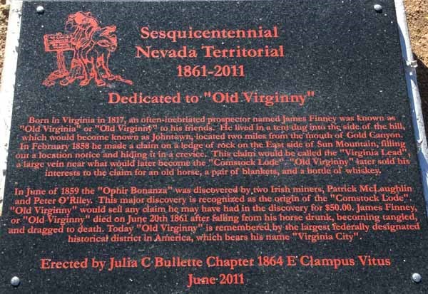
Dedicated to “Old Virginny”
Born in Virginia in 1817, an often-inebriated prospector named James Finney was known as “Old Virginia” or “Old Virginny” to his friends. He lived in a tent dug into the side of the hill, which would become known as Johntown, located two miles from the mouth of Gold Canyon. In February 1858 he made a claim on a ledge of rock on the East side of Sun Mountain, filling out a location notice and hiding it in a crevice. This claim would be called the “Virginia Lead”, a large vein near what would later become the “Comstock Lode”. “Old Virginny” later sold his interests to the claim for an old horse, a pair of blankets, and a bottle of whiskey.
In June of 1859 the “Ophir Bonanza” was discovered by two Irish miners, Patrick McLaughlin and Peter O’Riley. This major discovery is recognized as the origin of the “Comstock Lode”. “Old Virginny” would sell any claim he may have had in the discovery for $50.00. James Finney, or “Old Virginny” died on June 20th 1861 after falling from his horse drunk, becoming tangled, and dragged to death. Today “Old Virginny” is remembered by the largest federally designated historical district in America, which bears his name “Virginia City”.
Erected by Julia C Bullette Chapter 1864 E Clampus Vitus
June 2011
Location: 39°13’59.2″N 119°35’46.9″W. 11S E 275900 N 4345859
Quick Description: E Clampus Vitus plaque in the Dayton Cemetery, Dayton, NV.
Flumes in Sierra Mountains
This plaque will be installed near the Mt. Rose Ski Resort on Slide Hill sometime in the future.
Julia’s Golden Anniversary

The Pioneer Church

Inscription. The first religious service in Nevada, officiated by a visiting Protestant Episcopal Reverend, was held in Virginia City’s U.S. Courthouse on Sept. 11, 1861. A Parish was organized as St. Paul’s Protestant Episcopal. In the following year the Rev. Franklin S. Rising became St. Paul’s first Pastor and missionary, also holding services in Gold Hill and Silver City. A $30,000.00 church was built and the first service was held on Feb. 22, 1863. It was destroyed in the great fire of 1875 and rebuilt the following year on the original site.
The gothic style St. Paul’s Episcopal Church’s interior is adorned with hand-hewn pine beams and sugar pine planking from Lake Tahoe. The pipe organ, the oldest in Nevada, cost $3,000.00 and came around the “Horn”. St. Paul’s Parish, founded in 1861 is still active and holds Sunday services year round.
Erected 2014 by Julia C. Bulette Chapter 1864 E Clampus Vitus.
Marker series. This marker is included in the E Clampus Vitus marker series.
Location. 39° 18.551′ N, 119° 38.876′ W. Marker is in Virginia City, Nevada, in Storey County. Marker is on South F Street, on the left when traveling south. Touch for map. Marker is at or near this postal address: 87 South F Street, Virginia City NV 89440, United States of America.
Belmont Courthouse

Location: Belmont Courthouse, Manhattan, NV 89022. 38°35’46.6″N 116°52’33.3″W
The Reno Depots
Inscription: Myron Lake, owner of the nearby toll bridge, deeded acreage to the Central Pacific Railroad to locate the depot at this site.
In April 1868 the CPRR platted the area and on May 9th auctioned the lots and constructed a utilitarian wood depot. The railroad reached Reno in June and shortly afterwards the original station was replaced by the much grander wood framed Depot Hotel. This two story building had the best rooms and restaurant in early Reno. In 1871 the Virginia and Truckee Railroad laid tracks to the Depot Hotel, and a third floor was added in 1876. The addition burned the following year and was quickly repaired. The Great Fire of 1879 completely destroyed the building. That same year a larger and even grander Depot Hotel was built with three stories, 47 rooms, a bar, and offices for both railroads. The Depot Hotel once again burned to the ground in 1889. The CPRR decided not to fund another Depot Hotel, instead building a small brick one story station with a slate roof.
In 1926 the Southern Pacific Railroad replaced the station with a more traditional depot at the east end of this block. An annex was built on the west end of the Depot to provide access to the lowered tracks. Amtrak officially moved into the former SP station in January 2006.
Dedicated June 26, 6020 (2015)
Julia C. Bulette Chapter
E Clampus Vitus
Location: Reno Amtrak Station, 280 N Center St, Reno, NV 89501. 39.5282766N ,-119.8114668W
The Virginia Street Bridges

In 1859, one of the area’s early residents, Charles W. Fuller, built a dwelling on the south side of the Truckee River where the third Riverside Hotel now stands. He constructed a seventeen mile crude sketch of road in the region and received permission to collect tolls. The following year he built a wooden bridge across the river along this route. The winter of 1862 had considerable flooding and this bridge, along with all the others along the Truckee, was swept away. The following year, Myron C. Lake purchased the property from Fuller and replaced the bridge. Four years later, it too was damaged by high water, and was rebuilt by Lake. The importance of the site, known temporarily as Lake’s Crossing, grew rapidly with the 1859 discovery of the Comstock Lode. With the coming of the railroad none years later, the crossing was renamed by Charles Crocker, “Reno” after Civil War hero, Major General Jesse Lee Reno. The famous “Iron Bridge” was to follow in 1877. The span was moved from Virginia Street to Rock Street in 1905 when it was replaced with a more attractive concrete structure. This new crossing’s low design was partially responsible for heavy flooding of downtown Reno in 1950, 1955 and 1997. Lasting over a century, this venerable bridge was demolished in 2015 to make way for a fifth known river crossing at this location.
Dedicated June 24, 6021 (2016)
Julia C. Bulette Chapter
E Clampus Vitus
Location: Bruka Theater, 99 N Virginia Street, Reno, NV 89501 39° 31.533′ N, 119° 48.783′ W
Virginia City’s Oldest Church
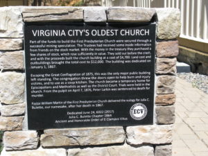
Inscription: Part of the funds to build the First Presbyterian Church were secured through a successful mining speculation. The Trustees had received some inside information from friends on the stock market. With the money in the treasury they purchased a few shares of stock, which rose sufficiently in value. They sold out before the crash and with the proceeds built the church building at a cost of $4,700 land cost and outbuildings brought the total cost to $12,000. The building was dedicated on January 1, 1867.
Escaping the Great Conflagration of 1875, this was the only major public building left standing. The congregation threw the doors open to help burn and injury victims, and to use as a soup kitchen. The church became a temporary home for Episcopalians and Methodists as well as the District Court. Trials were held in the church. From the pulpit on April 7, 1876, Peter Larkin was sentenced to death for murder.
Pastor William Martin of the First Presbyterian Church delivered the eulogy for Julia C. Bulette, our namesake, after her death in 1867.
Dedicated June 24, 6022 (2017)
Julia C. Bulette Chapter 1864
Ancient and Honorable Order of E Clampus Vitus
Location: 196 South C Street, Virginia City, NV 89440. 39.3081346 N, -119.6507392 W
Harry Wade Exit Route

Courtesy of the Death Valley 49ers and Marvin Jensen.
Inscription. Some 100 wagons found themselves in Salt Lake City too late to cross the Sierra Nevada. They banded together under the name of Sand Walking Co. and started for the gold fields in California over the old Spanish Trail. After being in Death Valley with the ill-fated 1849 caravan, Harry Wade found this exit route for his ox-drawn wagon, thereby saving his life and those of his wife and children. At this point the Wade party came upon the known Spanish trail to Cajon Pass.
Lower Plaque:
This plaque was replaced by Sam Brannan, Julia C Bulette, Yerba Buena, Lost Dutchman, Billy Holcomb, Platrix, John P. Squibob, and Chief Truckee chapters of “The Ancient and Honorable Order of E Clampus Vitus”
Erected 1957 by Descendants of Harry Wade, Death Valley 49ers, San Bernardino County, Ca. State Parks Comm., and E Clampus Vitus Chapter #s 1,2,1004,1864,1069,1853,3691 and 5917+4. (Marker Number 622.)
Marker series. This marker is included in the E Clampus Vitus marker series.
Location. 35° 37.975′ N, 116° 17.45′ W. Marker is near Baker, California, in San Bernardino County. Marker is at the intersection of Death Valley Road (California Route 127 at milepost 29.8) and Saratoga.
Gold Hill

Inscription. The first prospectors and settlers came to this area in 1852, but Gold Hill was not formally settled until 1858. The following year, with the discovery of silver, Gold Hill became a major community. Never as prominent as Virginia City, Gold Hill still boasted of its big mines, churches, banks, schools, newspapers, and some 8,000 residents in 1875. Continuous competition between the two towns kept Gold Hill lively for many years, until mining began to decline in the 1880’s.
Erected by E Clampus Vitus, Julia C. Bulette Chapter No. 1864.
Marker series. This marker is included in the E Clampus Vitus marker series.
Location. 39° 17.651′ N, 119° 39.453′ W. Marker is in Gold Hill, Nevada, in Storey County. Marker is on Main Street. Touch for map. Marker is in this post office area: Virginia City NV 89440, United States of America.
In The Span of One Lifetime
The rumor was that the following text was to be etched onto a plaque and sometime in 2018 would be placed in the Eldorado Canyon pine nut wood ranch where Fannie Gore Hazlett lived during the Comstock era. –Metric
In 1862 Fannie Gore, age 24, a single woman, camped where the Dayton Depot now stands, on her way West. She traveled 16 weeks by mule team along the Emigrant Trail to reach her destination. She was joined in this camp by 30 miners and 200 local indigenous people (Paiute). She wrote about the experience, “This is mining country and the society is rough, with frequent shooting affrays. There is drinking and gambling at every door and there are about 20 men to one woman.”
In 1864 Fannie married Dr. John Clark Hazlett. She went on to write the Historical Sketch of Dayton, published in the 1921-22 Nevada Historical Society Papers. She supported women’s suffrage, and served as a postmaster in Dayton where she organized a library. She met Brigham Young and Mark Twain and socialized with many Nevada governors and legislators.
At age 84 Fannie Gore Hazlett made national news as the oldest woman to ever fly in an aeroplane. From a true pioneer to aeroplane passenger, Fannie lived to 95.
Michelson Residence

Albert Michelson (1852-1931) lived at this location with his family after graduating high school in San Francisco in 1869. By directly speaking with then president Ulysses S. Grant, he won a spot to attend Annapolis. After graduation, he once again returned to his home before reporting to sea duty. In 1907, Albert Michelson became the first American
to receive the Nobel Prize for Science, primarily for his measurements of the speed of light. He died in 1931 in Pasadena, Cal.
Location: 42 North A Street,Virginia City, NV. 39°18’41.2″N 119°39’02.4″W
Dedicated August 4, 2020.
Empire

Location: Mile Marker 66, Rte 447, near the entrance to Empire Mining Company
The Yellow Jacket Mine Fire
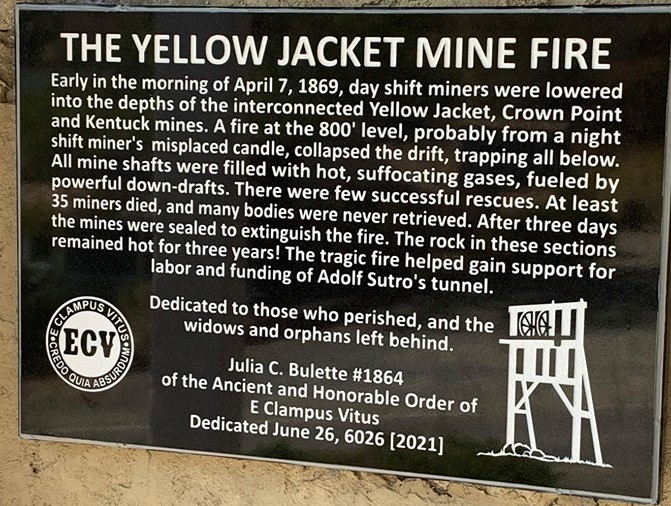
Early in the morning of April 7, 1869, day shift miners were lowered into the depths of the inter connected Yellow Jacket, Crown Point and Kentuck mines. A fire at the 800′ level, probably from a night shift miner’s misplaced candle, collapsed the drift, trapping all below. All mine shafts were filled with hot, suffocating gases, fueled by powerful down-drafts. There were few successful rescues. At least 35 miners died, and many bodies were never retrieved. After three days the mines were sealed to extinguish the fire. The rock in these sections remained hot for three years! The tragic fire helped gain support for labor and funding of Adolf Sutro’s tunnel.
Dedicated to those who perished, and the widows and orphans left behind.
Julia C. Bulette #1864
of the Ancient and Honorable Order of
E Clampus Vitus
Dedicated June 26, 6026 [2021]
The Misfits

The Misfits is a contemporary western drama filmed in 1960 and is best known for the final film roles of movie legends Clark Gable and Marilyn Monroe. It was directed by John Huston and written by playwright Arthur Miller. In 1956, Miller resided outside of Reno and was insprired by Nevada’s vast desert landscapes, wild mustangs and local residents. The Misfits stars Clark Gable, Marilyn Monroe, Eli Wallach, Montgomery Clift, and Thema Ritter. Miller wrote the screenplay specifically for Monroe, his wife at the time.
The Misfits’ plot centers on Monroe’s character, a recently divorced Roslyn Taybor and her new forlorn friends who go to the Dayton rodeo and come up with a plan to wrangle a herd of wild “misfit” mustangs. The film’s highlight, where the actors wrangle the wild mustangs was shot on a dry lake bed near Stagecoach, 16 miles east of Dayton, now referred to as “Misfits Flats”.
The film’s bar and rodeo scenes were filmed in downtown Dayton. Marilyn Monroe’s famous paddle ball scene, in which she is accompanied by the rest of cast, was shot here inside the Odean Hall and Saloon. Other local filming locations included the Washoe County Court House, the Truckee River, Harrah’s Hotel and Casino, Quail Canyon, and Pyramid Lake. During production, the cast stayed in Reno at the Mapes Hotel. Filming of The Misfits was completed on November 4, 1960, twelve days before the death of Clark Gable. The Misfits was released on February 1, 1961. Marilyn Monroe would not complete another film in her acting career. She passed away in August of 1962.
39° 14.22′ N, 119° 35.464′ W. Marker is in Dayton, Nevada, in Lyon County. Marker is on Pike Street south of Tyler Street, on the right when traveling south. Touch for map. Marker is at or near this postal address: 65 Pike Street, Dayton NV 89403, United States of America. Touch for directions
Dowling’s Blacksmith Shop
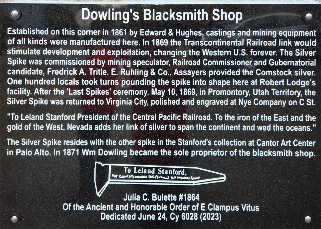
Established on this corner in 1861 by Edward & Hughes, castings and mining equipment of all kinds were manufactured here. In 1869 the Transcontinental Railroad link would stimulate development and exploitation, changing the Western U.S. forever. The Silver Spike was commissioned by mining speculator, Railroad Commissioner and Gubernatorial candidate, Fredrick A. Tritle. E.Ruhling & Co., Assayers provided the Comstock silver. One hundred locals took turns pounding the spike into shape here at Robert Lodge’s facility. After the “Last Spikes’ ceremony, May 10, 1869, in Promontory, Utah Territory, the Silver Spike was returned to Virginia City, polished and engraved at Nye Company on C St “To Leland Stanford President of the Central Pacific Railroad. To the iron of the East and the gold of the West, Nevada adds her link of silver to span the continent and wed the oceans.” The Silver Spike resides with the other spike in the Stanford’s collection at Cantor Art Centerin Palo Alto. In 1871 Wm Dowling became the sole proprietor of the blacksmith shop.
To Leland Stanford
Julia C. Bulette #1864
Of the Ancient and Honorable Order of E Clampus Vitus
Dedicated June 24, Cy 6028 (2023)
Location: 39 18 34.930 N, 119 39 2.514 W
Washoe City Cemetery

Location: 39.324230,-119.812995
Year Humbug Subject Plaqued
1963 Louie Beaupre* Julia C. Bulette
1964 Marsh Fey Ill Fated Brothers (Grosh)
1965 John Dufresne* Old Miners Union Hall
1966 Jim Lydon Gold Hill Hotel
1967 Jack Cross* Johntown
1968 Leo Gervais Lousetown & Lakes Crossing
1968 Ed Lydon The Warren Engine Co
1969 Don Olson* Mound House
1969 Bob
1970 Dail Turney* Gold Hill Millionaires
1971 Jim Williams Nevada Brewery
1972 Swede Hansen* The Nevada Bank of San Francisco
1973 Tom Ozburn* Big Bonanza
1974 Rod Stock Odeon Saloon-Billiard Parlour
1975 Tiny Sira Great Seal of the State of Nevada
1976 Russ Diemert* Jumbo (West Comstock)
1977 Click Slocum* Widows and Orphans Abide
1978 Wayne Wright Original Silver Discovery
1979 Chip Gash* Fort Homestead
1980 Geno Oliver* Ships of the Nevada Desert
1981 Skip Pennington* Dayton Carson Valley Sutro Railroad
1982 Bill Kennedy Restoration Jumbo Plaque
1983 Jim Cronn* American City
1984 George Courson Brunswick Ledge
1985 Doug Walling International Hotel
1986 David Wood Union Brewery
1987 Joe Leopri* Phillip Deidesheimer
1988 Bill Sawyer* Frank Bell
1989 Mike Miller Restoration of Nevada Brewery
1990 Red Beach* McCarran Ranch
1991 Bob Rodgers Hayes Store
1992 Ron Walsh The Crystal Saloon
1993 Danny Costella Mary Jane Simpson
1994 Jim Grows Dan DeQuille
1995 Daniel Bowers E Clampus Vitus Building
1996 Peter Van Alstyne* The 601’s
1997 Eddy Gonzalez V &T Railroad
1998 John Dornstauder William Sharron
1999 Ken Moser The Town of Dayton
2000 Val Collier Gold Hill Cemetery
2001 Chuck Murray Blackwell Ponds
2001 Old Globe Saloon
2002 Marc Bebout* Pony Express Route / New Pass Mine
2003 Nick Nichelson St. Mary’s Hospital
2004 Ron Thorton Great Fire of 1875
2005 J. D. Paterson Founding Fathers of JCB
2006 Walt Simeroth Alfred Doten
2007 Jeff Johnson Union Miners Hall
2008 Owen Ritchie John William Mackay
2009 Karl Small Virginia City Sesquicentennial
2010 Dan Weston Tonopah Mining Boom
2011 Russ Bream Old Virginny
2012 Jess Davis Flumes in the Sierra Mountains
2013 Cliff McCain Julia Bulette Golden Anniversary
2014 Bob Stransky Pioneer Church
2015 Tim Pearce The Reno Depots
2016 Kevin Breckinridge The Virginia Street Bridges
2017 Reid Slayden Virginia City’s Oldest Church
2018 Doc Asher Fanny Gore Halzell – “The Span of a Lifetime”
2019 Victor Mena Michelson Residence
2020 Matthew Ebert Empire
2021 Fred Eldred The Yellow Jacket Mine Fire
2022 Travis Stransky The Misfits
2023 Rob Day Dowling’s Blacksmith Shop
SOURCES:
Historical Marker Database: http://hmdb.com
Waymarking: http://www.waymarking.com/
Castro, Kenneth M., Clamplaquero & Fambrini, Eugene L. “Geno,” Clamphotographer. “E Clampus Vitus Plaques: A compilation of historical plaques with photographs dedicated by the Ancient and Honorable Order of E Clampus Vitus, 1930 – 1995.” Historic Sites and Plaques Committee, The Grand Council of E Clampus Vitus. Harrington McInnis Printers, Oakland, CA 1995.
Blumner, Sidney M. XSNGH, Clamplaquero & Gavigan, Rick NGH. “E Clampus Vitus Plaques: 1994 – 2007. A compilation of historical plaques with photographs dedicated by the Ancient and Honorable Order of E Clampus Vitus, 1994 – 2007.” E Clampus Vitus, Inc. 2009.
Blumner, Sidney M. XSNGH, Clamplaquero & Gavigan, Rick NGH. “E Clampus Vitus Plaques: 1994 – 2007. A compilation of historical plaques with photographs dedicated by the Ancient and Honorable Order of E Clampus Vitus, 1994 – 2007.” E Clampus Vitus, Inc. 2009.